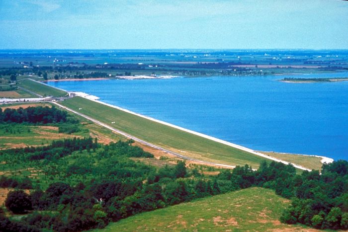
Carlyle Lake
Park Information
Carlyle Lake is located on the Kaskaskia River, approximately 107 miles above its mouth, near the community of Carlyle, Illinois.
Carlyle Lake is the largest man-made lake in Illinois, with over 26,000 acres of water and 11,000 acres of public land. The Carlyle Lake Project provides flood control, water quality control, and water supply to nearby communities, recreation, fish and wildlife conservation, and navigation.
Three marinas, 18 public boat ramps, a sailboat harbor, two State Parks, one with cabins, a resort with lodge, cabins and a restaurant, four beaches, five federal campgrounds, two state campgrounds, a visitor center, and numerous outlying areas provide a variety of opportunities for outdoors enthusiasts.
Agency Name:
US Army Corps of Engineers
Directions
Carlyle Lake is located approximately 50 miles east of St. Louis, Missouri on U.S. Highway 50. The lake area is well served by the existing highway system with U.S. 51 providing access from the east and Illinois 127 providing access from the west. Three major interstates, 70, 64, and 57 are within short driving distances from the lake.
Geographic Location
Contact Info
801 LAKE ROAD
Carlyle, IL
62231-9703
Near By Parks
- George Rogers Clark National Historical Park
- Jefferson National Expansion Memorial
- Lincoln Home National Historic Site
- Ulysses S Grant National Historic Site
- Clark County Museum
- Great River National Wildlife Refuge
- Middle Mississippi River National Wildlife Refuge
- Two Rivers National Wildlife Refuge
- Lake Shelbyville
- Marion Reservoir
- Shawnee National Forest
- Clarence Cannon National Wildlife Refuge
- Crab Orchard National Wildlife Refuge
Near By Campgrounds
- Beaver Dam State Park
- Benton KOA
- Boulder Day Use (IL)
- Boulder Rec. Area (IL)
- Casey KOA
- Clinton Lake State Recreation Area
- Coles Creek Day Use (IL)
- Coles Creek Rec Area (IL)
- Coon Creek (IL)
- Dale Miller Youth (IL)
- Dam East (DAY USE) (Il)
- Dam East Rec. Area (DAY USE) (Il)
- Dam East Spillway (DAY USE) (Il)
- Dam West (DAY USE) (Il)
- Dam West Area (DAY USE) (Il)
- Dam West Day Use (IL)
- Dam West Rec. Area (CAMP AND DAY) (Il)
- Dam West Spillway (IL)
- Eagle Creek State Recreation Area
- Edward Madigan State Fish And Wildlife Area
- Eldon Hazlet State Recreation Area
- Ferne Clyffe State Park
- Forrest W. Bo Wood (DAY USE) (Il)
- Forrest W. Bo Wood (IL)
- Fox Ridge State Park
- Frank Holten State Recreation Area
- Giant City State Park
- Gun Creek (IL)
- Hamilton County State Fish And Wildlife Area
- Hidden Springs State Forest
- Horseshoe Lake Madison State Park
- Jim Edgar Panther Creek State Fish And Wildlife Area
- Keyesport Rec. Area (IL)
- Lake Murphysboro State Park
- Lincoln Trail State Park
- Lithia Springs (IL)
- Lone Point (DAY USE) (Il)
- Lone Point (IL)
- Lotus Group Area (IL)
- Mcnair Group Area (IL)
- North Marcum Day Use Area (IL)
- North Sandusky Campground (IL)
- North Sandusky Day Use (IL)
- Opossum Creek (IL)
- Pere Marquette State Park
- Ramsey Lake State Recreation Area
- Randolph County State Recreation Area
- Red Hills State Park
- Sam Dale Lake State Fish And Wildlife Area
- Sam Parr State Fish And Wildlife Area
- Sangchris Lake State Recreation Area
- Shagbark Group Area (IL)
- South Marcum Campround (IL)
- South Marcum Day Use (IL)
- South Sandusky Campground (IL)
- South Sandusky Day Use (IL)
- Spillway (IL)
- Stephen A. Forbes State Recreation Area
- Trail Of Tears State Forest
- Walnut Point State Park
- Washington County State Recreation Area
- Wayne Fitzgerrell State Recreation Area
- Weldon Springs State Park
- Wilborn Creek (GROUP CAMP) (Il)
- Wolf Creek State Park
- World Shooting Complex
- Harmonie
- St. Louis N.E. I 270 Granite City KOA
- St. Louis West Historic Route 66 KOA
- Bootleg (UT)
- Cats Paw Camp (UT)


![How To Pick The Best Camper Levelers? [An Ultimate Buyer’s Guide] Best Camper Levelers](https://packyourgear.com/images/Best-Camper-Levelers-100x70.jpg)


