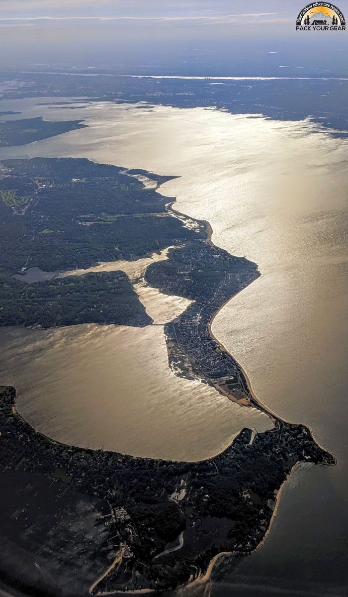
Oyster Bay National Wildlife Refuge
Park Information
The Oyster Bay NWR on the north shore of Long Island consists of high quality marine habitats that support a variety of aquatic-dependent wildlife.
The refuge’s waters and marshes surround Sagamore Hill National Historic Site, home of Theodore Roosevelt – father of the National Wildlife Refuge System.
Subtidal (underwater up to mean high tide line) habitats are abundant with marine invertebrates, shellfish and fish. Marine invertebrate and fish communities support a complex food web from waterfowl to fish-eating birds, to marine mammals.
Waterfowl use of the Refuge peaks from October through April. Over 20,000 ducks have been documented on the refuge during one survey.
Over 25 species of waterfowl, along with numerous other waterbirds, depend on Oyster Bay for survival. The most common marine mammals at the refuge are harbor seals – which have become more noticeable during recent years.
Sea turtles and diamondback terrapins can also be sighted at the Refuge. New York State’s only remaining commercial oyster farm operates on the refuge, producing 90% of the State’s oyster harvest.
Agency Name:
Fish and Wildlife Service
Directions
Access to the refuge is limited to private boats and rentals. Residents outside of Oyster Bay may enter the refuge by boat from Long Island Sound. Visitors in vehicles may travel local roads adjacent to the refuge. The refuge does not provide parking. Mill Pond, part of the Refuge, is located off West Main Street. Onsite parking is not available.
Geographic Location
Contact Info
N/A
Oyster Bay, NY
11771
Near By Parks
- National Parks of New York Harbor
- Hunt Hill Farm
- Delaware National Scenic River
- Delaware And Lehigh National Heritage Corridor
- Delaware Water Gap National Recreation Area
- Edison National Historic Site
- Ellis Island National Monument
- Eleanor Roosevelt National Historic Site
- Federal Hall National Memorial
- Fire Island National Seashore
- Gateway National Recreation Area
- General Grant National Memorial
- Hamilton Grange National Memorial
- Home Of Franklin D Roosevelt National Historic Site
- Lower East Side Tenement Museum National Historic Site
- Morristown National Historical Park
- Sagamore Hill National Historic Site
- Saint Pauls Church National Historic Site
- Springfield Armory National Historic Site
- Statue Of Liberty National Monument
- Theodore Roosevelt Birthplace National Historic Site
- Vanderbilt Mansion National Historic Site
- Weir Farm National Historic Site
- Hudson River National Estuarine Research Reserve
- Jacques Cousteau National Estuarine Research Reserve
- Manhattan Sites
- Museum of American Financial History
- National Museum Of Industrial History
- The Jazz Museum In Harlem
- Western Connecticut State University
- Shawangunk Grasslands National Wildlife Refuge
- Seatuck National Wildlife Refuge
- Elizabeth A. Morton National Wildlife Refuge
- Governors Island National Monument
- Lincoln Park Coast Cultural District
- Great Swamp National Wildlife Refuge
- Stewart B. Mckinney National Wildlife Refuge
- Target Rock National Wildlife Refuge
- Wallkill River National Wildlife Refuge
- Wertheim National Wildlife Refuge
- Success Lake
- Cooper Hewitt National Design Museum
- Huntington State Park
- Appalachian National Scenic Trail
- Castle Clinton National Monument
- Colebrook River Lake
- Hancock Brook Lake
- Hop Brook Lake
- Mansfield Hollow Lake
- Northfield Brook Lake
- Thomaston Dam
- Delaware Lake
- Union City Dam
- Amagansett National Wildlife Refuge
- Elizabeth A. Morton Nwr
Near By Campgrounds
- American Legion Sf (HAWES)
- Black Rock Picnic Shelter
- Black Rock State Park
- Burr Pond Picnic Shelter
- Chatfield Picnic Shelters
- Day Pond Picnic Shelter
- Dennis Hill Picnic Shelter
- Devils Hopyard
- Devils Hopyard Picnic Shelter
- Dinosaur State Park Picnic Shelter
- Hammonasset Beach State Park
- Hammonasset Picnic Shelter
- Hopeville Pond State Park
- Housatonic Meadows State Park
- Indian Well Picnic Shelter.
- Kettletown State Park
- Lake Waramaug State Park
- Macedonia Brook Picnic Shelter
- Macedonia Brook State Park
- Mystic KOA
- Northfield Brook Lake (CT)
- Osbornedale Picnic Shelter
- Penwood Picnic Shelter
- People&Amp;Apos;S Forest Picnic Shelter
- Rocky Neck Picnic Shelter
- Rocky Neck State Park
- Seaport
- Sleeping Giant Picnic Shelter
- Southford Picnic Shelter
- Stratton Brook Picnic Shelter
- Wharton Brook Picnic Shelter
- Beartown State Forest
- Granville State Forest
- Tolland State Forest
- Beaver Pond Campsite
- Camp Gateway (NY)
- Camp Waubeeka
- Clarence Fahnestock State Park
- Cold Brook
- Devils Tombstone Campground
- Hither Hills State Park
- Kenneth L. Wilson
- Lake Taghkanic
- Mills Norrie State Park
- Mongaup Pond
- Newburgh New York City North KOA
- North South Lake Campground
- Roundout Valley Rv
- Saugerties Woodstock KOA
- Sebago Cabins
- Taconic (COPAKE FALLS)
- Taconic State Park (RUDD POND AREA)
- Wildwood State Park
- Woodland Valley
- Delaware Water Gap Pocono Mountain KOA
- Scotrun Campground
- Timothy Lake North


![How To Pick The Best Camper Levelers? [An Ultimate Buyer’s Guide] Best Camper Levelers](https://packyourgear.com/images/Best-Camper-Levelers-100x70.jpg)


