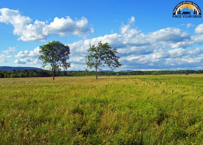
Shawangunk Grasslands National Wildlife Refuge
Park Information
Shawangunk Grasslands National Wildlife Refuge is one of New York’s top 10 areas for grassland dependent migratory birds. This exceptional habitat was formerly the Galeville Military Airport.
In 1994, the U.S. Department of Defense determined it longer needed the site. It was subsequently transferred to the U.S. Fish and Wildlife Service in 1999. The refuge is 566 acres.
It is located in the valley below the Shawangunk Mountains near the Hamlet of Wallkill in the Town of Shawangunk, Ulster County, New York. Visitors are rewarded with spectacular views of the Shawangunks as well as many species of grassland birds.
This is an unstaffed satellite of the Wallkill River NWR. Call 973-702-7266 for more information. Keeping this grassland and controlling the invasion of weeds, woody shrubs, and trees is the highest management priority for the refuge.
Even though human created, this grassland is increasingly important for grassland-dependent migratory birds. As part of its management strategy, the refuge strives to restore and expand the habitats of six species of declining migratory birds that currently or historically occupied the refuge.
Bobolink, Savannah sparrow, Grasshopper sparrow, Upland Sandpiper, Northern Harrier, and Short-eared Owl are the focus of refuge management.
Agency Name:
Fish and Wildlife Service
Directions
These directions are from I-84: At Exit #5 off Interstate 84, travel north on State Rt. 208. Enter the Village of Walden. At the stop light, turn right, continuing north on State Rt. 208. You will then travel into the Hamlet of Wallkill in Ulster County. At the stop sign, turn left on Wallkill Avenue. Travel for 2/10 mile. Turn left on Bruyn Turnpike / County Rt. 18 (Post Office on corner). At stop sign, continue straight on Bruyn Turnpike. Travel for 1.4 miles Turn right on Hoagerburgh Road. Travel for 1.5 miles, passing Blue Chip Farm. The Shawangunk Grasslands NWR will be on your right.
Geographic Location
Contact Info
Hoagerburgh Road
Shawangunk, NY
12589
Additional Info
- “Home – Shawangunk Grasslands – U.S. Fish and Wildlife Service”. Accessed July 02, 2020. Link.
Near By Parks
- National Parks of New York Harbor
- Hunt Hill Farm
- Delaware National Scenic River
- Delaware And Lehigh National Heritage Corridor
- Delaware Water Gap National Recreation Area
- Edison National Historic Site
- Ellis Island National Monument
- Eleanor Roosevelt National Historic Site
- Erie Canalway National Heritage Corridor
- Federal Hall National Memorial
- Fire Island National Seashore
- Gateway National Recreation Area
- General Grant National Memorial
- Hamilton Grange National Memorial
- Home Of Franklin D Roosevelt National Historic Site
- Lower East Side Tenement Museum National Historic Site
- Martin Van Buren National Historic Site
- Morristown National Historical Park
- Sagamore Hill National Historic Site
- Saint Pauls Church National Historic Site
- Saratoga National Historical Park
- Springfield Armory National Historic Site
- Steamtown National Historic Site
- Statue Of Liberty National Monument
- Theodore Roosevelt Birthplace National Historic Site
- Vanderbilt Mansion National Historic Site
- Weir Farm National Historic Site
- Hudson River National Estuarine Research Reserve
- Jacques Cousteau National Estuarine Research Reserve
- Manhattan Sites
- Museum of American Financial History
- National Museum Of Industrial History
- New York State Museum
- The Jazz Museum In Harlem
- Western Connecticut State University
- Seatuck National Wildlife Refuge
- Governors Island National Monument
- Lincoln Park Coast Cultural District
- Historic Bethlehem Partnership Inc.
- Great Swamp National Wildlife Refuge
- Oyster Bay National Wildlife Refuge
- Stewart B. Mckinney National Wildlife Refuge
- Target Rock National Wildlife Refuge
- Wallkill River National Wildlife Refuge
- Wertheim National Wildlife Refuge
- Success Lake
- Cooper Hewitt National Design Museum
- Huntington State Park
- Appalachian National Scenic Trail
- Castle Clinton National Monument
- Sherman Reservoir
- Aylesworth Creek Lake
- East Sidney Lake
- Beltzville Lake
- Prompton Lake
- Francis E Walter Dam
- Colebrook River Lake
- Hancock Brook Lake
- Hop Brook Lake
- Knightville Dam
- Littleville Lake
- Northfield Brook Lake
- Thomaston Dam
- Delaware Lake
- Union City Dam
- Elizabeth A. Morton Nwr
Near By Campgrounds
- American Legion Sf (HAWES)
- Black Rock Picnic Shelter
- Black Rock State Park
- Burr Pond Picnic Shelter
- Chatfield Picnic Shelters
- Day Pond Picnic Shelter
- Dennis Hill Picnic Shelter
- Devils Hopyard
- Devils Hopyard Picnic Shelter
- Dinosaur State Park Picnic Shelter
- Hammonasset Beach State Park
- Hammonasset Picnic Shelter
- Housatonic Meadows State Park
- Indian Well Picnic Shelter.
- Kettletown State Park
- Lake Waramaug State Park
- Macedonia Brook Picnic Shelter
- Macedonia Brook State Park
- Northfield Brook Lake (CT)
- Osbornedale Picnic Shelter
- Penwood Picnic Shelter
- People&Amp;Apos;S Forest Picnic Shelter
- Sleeping Giant Picnic Shelter
- Southford Picnic Shelter
- Stratton Brook Picnic Shelter
- Wharton Brook Picnic Shelter
- Beartown State Forest
- Clarksburg State Park
- Dar State Forest
- Granville State Forest
- Indian Hollow (MA)
- Mohawk Trail State Forest
- Mt. Greylock State Reservation
- October Mountain State Forest
- Pittsfield State Forest
- Savoy Mountain State Forest
- Tolland State Forest
- Windsor State Forest
- Bear Spring Mountain
- Beaver Pond Campsite
- Beaverkill
- Betty And Wilbur Davis State Park
- Camp Gateway (NY)
- Camp Waubeeka
- Chenango Valley State Park
- Cherry Plain State Park
- Clarence Fahnestock State Park
- Cold Brook
- Devils Tombstone Campground
- Gilbert Lake State Park
- Glimmerglass State Park
- Kenneth L. Wilson
- Lake Taghkanic
- Little Pond Campground
- Max V. Shaul
- Mills Norrie State Park
- Mongaup Pond
- Newburgh New York City North KOA
- North South Lake Campground
- Oquaga Creek
- Roundout Valley Rv
- Saugerties Woodstock KOA
- Sebago Cabins
- Taconic (COPAKE FALLS)
- Taconic State Park (RUDD POND AREA)
- Thompsons Lake State Park
- Unadilla I 88 Oneonta KOA
- Wildwood State Park
- Woodland Valley
- Delaware Water Gap Pocono Mountain KOA
- Scotrun Campground
- Timothy Lake North


![How To Pick The Best Camper Levelers? [An Ultimate Buyer’s Guide] Best Camper Levelers](https://packyourgear.com/images/Best-Camper-Levelers-100x70.jpg)


